What was Austin like before I-35?
This weekend, the missus and I decided to give ourselves a wedding present by acquiring a spanking new 2011 Kia Soul, in all of its hideous boxy, burnt orange glory. (The Wedding is a private ceremony this upcoming Friday, folks). For the last 72 hours or so, all I’ve been thinking about is cars.
Car cars cars. Thus, I thought it might be interesting to take a look at construction of a most important Austin thing: its roadways. And what roadway is more important tto Austin today than I35? The section of the IH-35 freeway that runs through Austin altered the shape of the city and more than doubled its annual population growth.
In the late 1940s, American engineers began to develop plans for the construction of a national highway that would run across the entire middle of the US. It would eventually stretch over 1,500 miles, crossing 7 states. The project opened its first section to motorists in 1956. Austin’s section was officially opened in 1962.
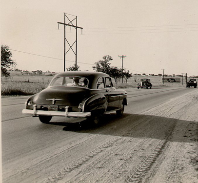
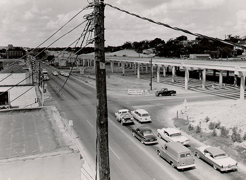
US-81 in South Austin heading south. US-81 was a small road that would eventually grow into IH-35. This picture is from sometime around 1949 to 1952.
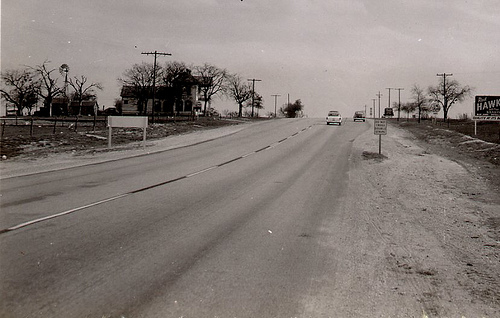
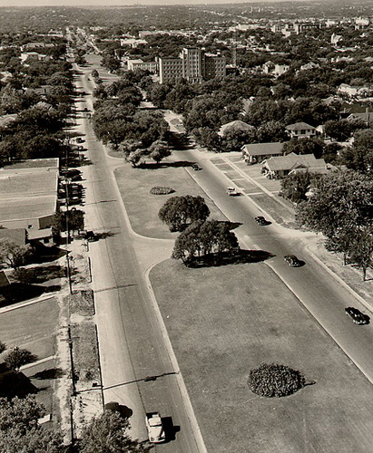
US-81 in North Austin proper looking North. This is the same road and would eventually turn into IH-35 as well.
It’s interesting to note the bareness of North and South Austin in these pictures. A brief aside: When we moved here from Ohio in May, we drove through a lot of empty-but-new Texas suburbs and talked about how it seems like Texas builds its roads before it builds its towns.
So much of Austin’s roadway was laid out well in advance of Austin’s growth. It was a gamble that has obviously paid off, but it also educates us as to why Austin is shaped the way it is — why its territorial girth far exceeds the reaches of the downtown populous.
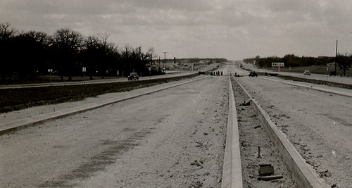
The silhouetted men in the distance are building an active cross-section to the Southern Pacific Railroad, which, until 1970, ran trains directly across Interstate 35. For roughly 8 years, motorists on the expressway would have to stop on a dime for a train crossing.
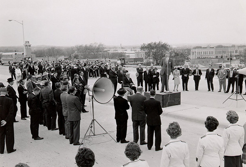
A 1962 opening ceremony for Austin's section of IH-35. There appears to be a marching band, some sort of small brigade of possible flight attendants, and various members of the media all wearing hats.
Obviously, the interstate was a major moment in the growth of the Capitol City. But it is also important to think about the lasting, damaging effects of such projects, and perhaps why the public transit debate in Austin is such a hot topic today.
This last picture is a photograph from a section of Austin roughly around present-day MLK Blvd. This picture is striking in that what you are seeing in this photo essentially does not exist today, as the area was completely restructured for the purpose of building IH-35 nearby. You’ll notice the clean, grass covered medians and the line of housing on the street. This, ladies and gentlemen, is what metropolitan American could look like before McMansions.
IH-35 is also a little infamous in Austin because it has long served as a racial dividing line. Research by the East End Cultural Heritage District web-site shows that Austin city planners had sought to create a “Negro District” in the East Austin in the late 1920s. Forty years later, at the height of the battle over civil rights, IH-35 became a literal barrier between east and west, and sadly, black and white. This is, unfortunately, a piece of Austin that still exists somewhat today. I can’t count how many times we were told when moving down here to steer clear of “East of 35″ — and I never really understood why.
I think this gets at the essence of what the writers at Republic of Austin are trying to accomplish here, with its commitment to clean, urban living, financial stability, understanding our history, social acceptance and so on. Austin remains one of America’s beautiful cities and can thank its commitment to modernness for that, but pre-IH 35 Austin also presents a very different, wholesome kind of attractiveness.
So while roads connect us — allow us to grow, it is important, especially for a place like Austin, to make sure we don’t lose that *something* that comes with being a unique American city — a special place in a special time. It’s important, in other words, to make sure the Kia Souls of Austin don’t replace the actual souls.
The next time we talk, I’ll be: Mr. Matthew Stewart, Married Person. I’ll let ya know if it feels any different.
-
Was the growth of major roadways in Austin bad for its cultural identity?
Are the folks in far North and far South Austin *real* Austinites?
Would expanding the highways in Austin help or hurt in “Keeping Austin Weird”?
—
Photos courtesy TexasFreeway.com
No related posts.
Related posts brought to you by Yet Another Related Posts Plugin.



Twitter Comment
ROA What was Austin like before I-35?:
This weekend, the missus and I decided to give ourselves… [link to post] via @ATX4U
- Posted using Chat Catcher
The old road is US-81, not I81.
Hey M1EK. Thanks for stopping by-and thanks for pointing out our error! It’s fixed.
M1EK,
Thanks for the comment! US 81 was a member of the National System of Interstate Highways as of 1949 (before these photographs), but the signage on the road was never updated in the area in anticipation of construction on 35. So it was (read: in parts of the country, is), technically an “I”, but you’re right in remarking that for all intents and purposes, it was always known as US Route 81 here in Austin.
Thanks for pointing out the discrepancy!
Twitter Comment
What was Austin like before I-35? [link to post]
- Posted using Chat Catcher
I don’t really have anything to add to the growth debate, but just wanted to say terrific topic nonetheless. I love the old photos, especially the downtown one of 6th/7th, circa 1960.
Everything looks so commercially barren! I wonder where everyone ate back then? I guess it was the Nighthawk, Matt’s El Rancho, or just stay at home.
Congrats on the upcoming wedding - and I look forward to reading more of your posts of ROA.
Thanks for the kind remarks, Brad!
You have an interesting point that there was about a fourth or fifth of the population in Austin in the 50′s to 60′s, but far less than a fourth of fifth of the number of restaurants. Working hours were much better defined then, as well, so there were fewer families with multiple incomes who had different times for coming home, etc. This made it easier to sit down for a meal every night.
We’ll be sure to have a blast this weekend and I’m glad you enjoy the posts — I look forward to writing more.
Take care!
Thanks Matt. I have been long contemplating a documentary photo piece on US 81. Considering the importance of the “Meridian Highway,” spanning from Mexico to Canada (the US portion of the Pan-American Highway), little has been written about it. One thing that intrigues me in particular was how the highway changed the fortunes of towns along its route, for good and bad. I was reading the other day about how when the Dallas to Austin I-35 was being planned to replace US 81 the original alignment was to go through Taylor. The citizens resisted, while Round Rock lobbied for the highway to pass through the city. Well, one only needs to look at the two cities today to see what that meant to each when both cities got their way.
f.
Frank,
Thanks for reading. Great points! IH-35 has definitely had a profound impact on the highway towns that it runs along. It is sort of a 20th century version effect of what happened with the canal system in the Northeast in the 1800s. The ability for boats to reach the midwest from the Atlantic Ocean revolutionized the economy and brought people from far away places to regions that have never been inhabited by white settlers before. The major interstates of the 1900s revolutionized the economy and allowed descendents from many of those same pioneer families to travel South. It’s a fascinating thing to study!
I also took a look at your web-sites and noticed the signage from Avon, Ohio. I am originally from New York and went to school in Bowling Green, Ohio, so on many a trip home I would pass through Avon and Avon Lake. A pretty little town.